

Native American History of Lake Oconee: Rock Hawk, Rock Eagle and the Mounds
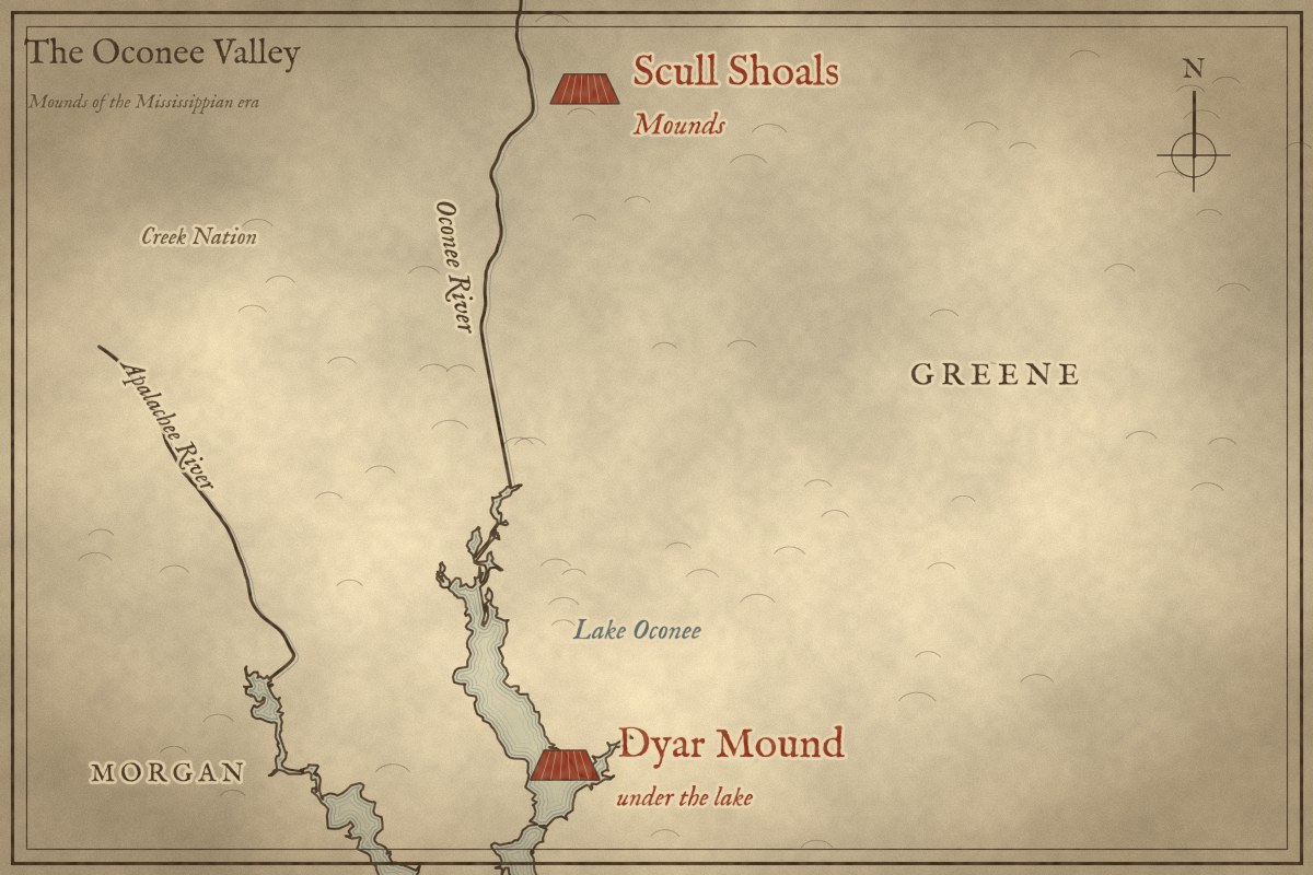
The Native American history of Lake Oconee is the story of the Oconee River valley that lies beneath it. For more than 10,000 years before the lake, people hunted, farmed, built towns and raised earthen mounds here. A Spanish army marched through in 1540. Later, the river became the border between Georgia and the Creek Nation. Today the river, the county and the lake all carry the name of the Oconee people who once lived here.
Key facts: Lake Oconee Native American history
- People lived along the Oconee River for more than 10,000 years before Lake Oconee, and Georgia Power’s relicensing filing dates the archaeological record to 10,800 years.
- University of Georgia archaeologists recorded 1,385 sites in the valley before Lake Oconee filled in 1979.
- The Dyar mound, about 34 feet tall, is under Lake Oconee, and a 2020 study found ceremonies there continued until about 1670.
- Spanish explorer Hernando de Soto marched through the chiefdom of Ocute, which ruled this stretch of the Oconee River, in April 1540.
- Rock Eagle and Rock Hawk, two bird-shaped stone effigies in Putnam County, are free to visit.
- The Oconee River was the border between Georgia and the Creek Nation from the 1790 Treaty of New York until the treaties of 1802 and 1805.
Lake Oconee Native American History at a Glance
| When | What happened along today’s Lake Oconee |
|---|---|
| About 9000 to 1000 BC | Hunters camp at the river shoals, leaving spear points, soapstone bowls and some of the earliest pottery in North AmericaUGA Wallace Reservoir reports |
| About AD 245 | A village on Cane Island at Long Shoals grows corn and squash, one of Georgia’s earliest farming villagesNew Georgia Encyclopedia |
| About AD 500 | A council house goes up at Cold Springs, near the mouth of Town CreekAmerican Antiquity, 2022 |
| About AD 1000 to 1200 | Work begins on the Dyar mound in Greene CountyUGA Laboratory of Archaeology |
| About 1350 to 1600 | The valley fills with farms, and the chiefdom of Ocute rules the river from near Milledgeville almost to AthensRudolph; New Georgia Encyclopedia |
| April 1540 | Spanish explorer Hernando de Soto’s army marches through the chiefdom of OcuteRodrigo Ranjel’s diary |
| To about 1670 | Ceremonies continue on the Dyar mound, more than a century after de SotoAmerican Antiquity, 2020 |
| About 1690 to 1715 | The Oconee people live on the river below today’s Milledgeville and give it their nameSwanton, 1922 |
| 1790 to 1802 | The Oconee River is the border between Georgia and the Creek NationTreaty texts; New Georgia Encyclopedia |
| 1802 to 1807 | The Creeks give up the land west of the river, and Morgan and Putnam counties are createdTreaty texts; New Georgia Encyclopedia |
| 1971 to 1979 | University of Georgia archaeologists survey the valley before Lake Oconee fillsRudolph; Georgia Power, 2015 |
Before Lake Oconee: Native American Life in the Oconee River Valley
Lake Oconee is a man-made lake. Georgia Power built Wallace Dam across the Oconee River in the 1970s. When the gates closed in 1979, the water spread for miles over the river channel, creek bottoms and farm fields. Before that, this was a river valley, and for most of human history in Georgia it was a good place to live. The river gave fresh water, fish and mussels, the bottomland soil was rich, and the river itself was a road north and south. Where the water ran shallow over rock, at shoals like Long Shoals and Lawrence Shoals, people crossed, fished and camped. They kept coming back to the same spots for thousands of years.
Most of what we know about the Native American history of Lake Oconee comes from a race against the rising water. Only eight archaeological sites were on record here before University of Georgia crews began walking the valley in the 1970s. By the time the lake filled, they had recorded 1,385 sites and more than 3,000 smaller finds. Georgia Power’s relicensing filing dates the human story here back 10,800 years. Most of those places are now underwater. Surveyors mapped the valley in 1972, and our interactive map of Lake Oconee before the lake lays that map over today’s shoreline.
The First Native American Hunters on the Oconee River
The first people reached the Oconee River more than 10,000 years ago, near the end of the last Ice Age. They were hunters and gatherers who moved with the seasons, following deer, gathering nuts and fishing the shoals. Archaeologists call this long stretch of time the Archaic period. Its people left spear points at their camps along the river. Later they carved heavy cooking bowls out of soapstone. More than 4,000 years ago, people on the Greene County bank were making Stallings Island pottery. It is some of the oldest pottery in North America.
Georgia’s Earliest Farmers at Cane Island and Cold Springs
Over time, people along the river began to settle down and plant crops. Around AD 245, a village on Cane Island at Long Shoals was growing corn and squash, which makes it one of the earliest farming villages in Georgia. Not far away, at Cold Springs near the mouth of Town Creek, people built low earthen mounds. Then, around AD 500, they raised a large council house where the community gathered to talk things over and decide together. University of Georgia researchers count it among the earliest council houses known in the Southeast. Cane Island and much of Cold Springs are now under Lake Oconee.
Rock Eagle and Rock Hawk: Native American Effigy Mounds Near Lake Oconee
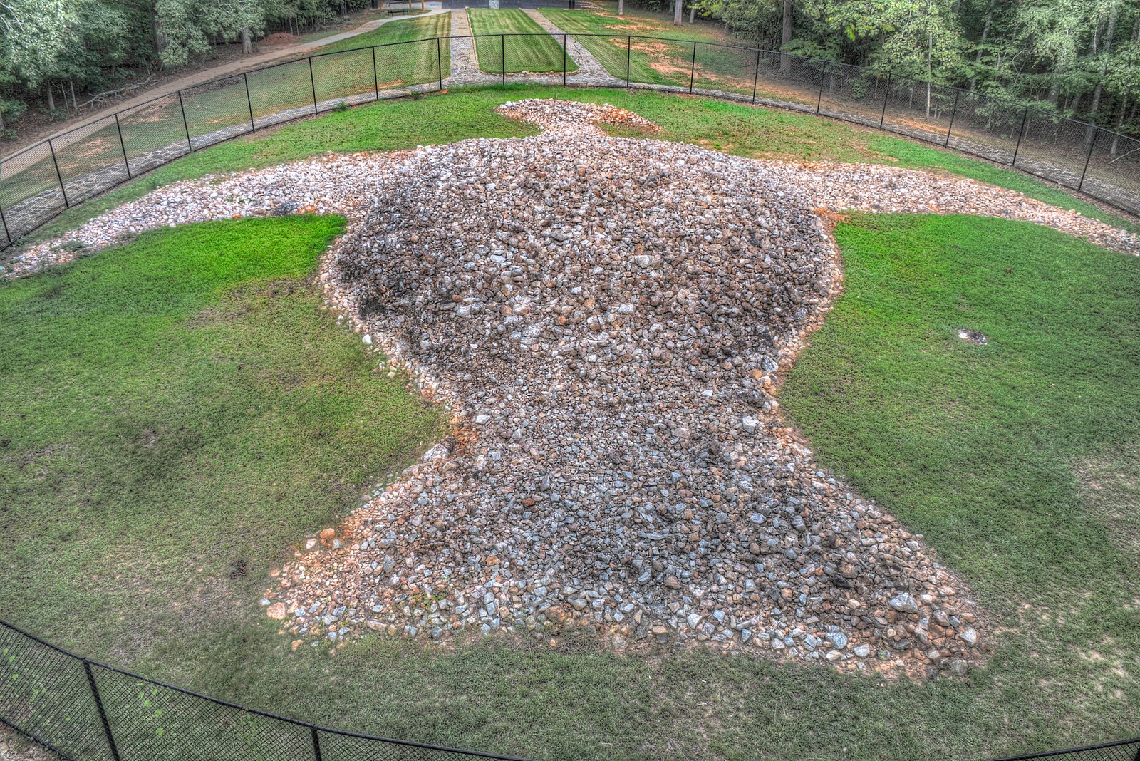
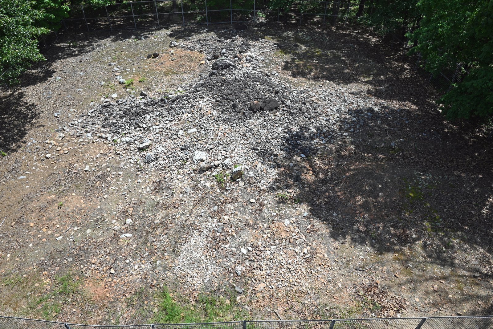
Archaeologists call this same era the Woodland period. During it, people in today’s Putnam County piled thousands of white quartz rocks into the shapes of two giant birds. Rock Eagle stretches about 102 feet from head to tail with a 120-foot wingspan, says the marker at the site. Its chest rises about 8 feet off the ground. Rock Hawk, its twin, sits near the shore of Lake Oconee. No one knows exactly who built them or why. Rock Eagle is probably about 2,000 years old. However, neither bird has been firmly dated, and estimates run from 1,000 to 3,000 years. University of Georgia researchers are now mapping both with lidar and drones, and the debate over their age is still open.
Rock Eagle and Rock Hawk are the best-known landmarks of the Native American history around Lake Oconee. Both are open to the public and free to visit. Rock Eagle is at the University of Georgia’s Rock Eagle 4-H Center, off Highway 441 between Eatonton and Madison. There, a stone tower built in the 1930s lets you look down on the whole bird. Rock Hawk is off Wallace Dam Road, a few minutes from the lake, with its own viewing tower and miles of hiking trails. Both birds are fenced, so you see them from the towers and the paths around them.
The Indian Mounds Under Lake Oconee
About a thousand years ago, a new way of life spread across the South. Archaeologists call it the Mississippian period. People lived in towns led by chiefs, farmed big fields of corn, and built tall, flat-topped earthen mounds with a temple or the chief’s house on top. A mound grew in layers, with fresh earth and a new building added every generation or so. That is how a pile of dirt became a hill.
The largest mound on this stretch of the Oconee River was the Dyar mound in Greene County, begun around AD 1100. When it was measured in 1975, it stood about 34 feet tall, about the height of a three-story building, and 171 feet across. It is now under Lake Oconee.
The valley went quiet for about 150 years after 1200, then filled with people again. By the 1400s and 1500s, small farmsteads lined the river and its creeks. The chiefdom of Ocute ruled the river from near Milledgeville almost to Athens, with mound towns up and down the valley.
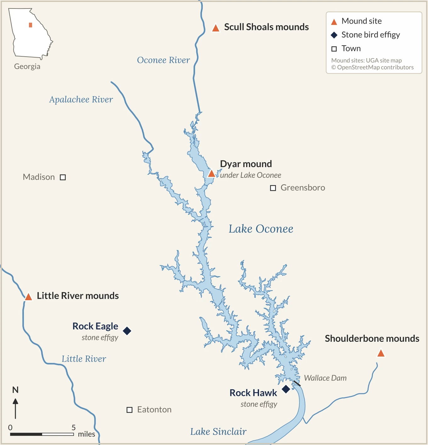
| Indian mounds near Lake Oconee | Where | Today |
|---|---|---|
| Dyar mound | Oconee River, Greene County | Under Lake Oconee; about 34 feet tall when measured in 1975 |
| Cold Springs mounds | Near the mouth of Town Creek | Partly under the lake, partly on national forest land |
| Cane Island village | Long Shoals | Under Lake Oconee |
| Scull Shoals mounds | Just upriver, in the Oconee National Forest | Main mound about 11 meters, or 36 feet, high |
| Little River mounds | Southern Morgan County | Four mounds and a village that was never plowed |
| Shoulderbone mounds | Hancock County, below Wallace Dam | Three mounds |
| Rock Eagle and Rock Hawk | Putnam County | Bird-shaped stone effigies, open to visitors |
Hernando de Soto in Georgia: The Spanish Reach the Oconee River
In the spring of 1540, the first Europeans ever to see the Oconee River came marching up from the south. They were led by Hernando de Soto, a Spanish conquistador who had grown rich helping Francisco Pizarro conquer the Inca Empire in Peru. Spain’s king made de Soto governor of Cuba and gave him the right to conquer La Florida, which to the Spanish meant the whole Southeast. In May 1539, he landed near Tampa Bay with more than 600 soldiers, horses, war dogs and a herd of pigs. He was hunting for gold and for another rich empire to take.
After a winter near today’s Tallahassee, the army turned north into Georgia. In early April 1540, it reached the Oconee River valley and the chiefdom of Ocute. De Soto’s secretary, Rodrigo Ranjel, kept a diary, and he wrote about each town they passed: Altamaha, Ocute, Cofaqui and Patofa. The chief of Ocute met the Spaniards with gifts and sent people to carry their supplies. Many historians believe Ocute’s main town was at the Shoulderbone mounds below today’s Wallace Dam. They also place Cofaqui at the Dyar mound, now under Lake Oconee, though no one can say for sure. From Patofa, the army pushed northeast through empty wilderness toward the chiefdom of Cofitachequi in South Carolina, chasing stories of gold it never found. De Soto died beside the Mississippi River in 1542.
The Dyar Mound That Outlasted de Soto
For decades, historians assumed the mound ceremonies along the Oconee ended soon after de Soto passed through. In 2020, a team led by archaeologist Jacob Holland-Lulewicz redated charcoal from the Dyar mound. They found that ceremonies there continued until about 1670, roughly 130 years after the Spanish came and went. Archaeology magazine named it one of the top 10 discoveries of 2020.
The end came soon after. European diseases spread through the Southeast in the 1600s. In the 1660s, the Westo, a tribe armed with English guns, raided the region and captured people to sell as slaves. By the 1670s, the old towns of the Oconee valley were empty, and the survivors had moved toward the coast and Spanish Florida.
Where Does the Name Oconee Come From?
Around 1690, a people called the Oconee settled on the river below today’s Milledgeville. They spoke Hitchiti, a language related to Muscogee, and were part of the larger group of towns the English called the Creeks. After the Yamasee War of 1715, they moved west to the Chattahoochee River. Around 1750, a band led by a man known as Cowkeeper went south to Florida’s Alachua savanna. That band became one of the roots of today’s Seminole people. What the word Oconee means has been lost. Still, their name lives on in the river, Oconee County, the Oconee National Forest and, since the 1970s, Lake Oconee.
When the Oconee River Was the Creek Nation Border
Through the 1700s, the land along the Oconee was Creek hunting ground. After the American Revolution, Georgia settlers pushed west to the river, and Greene County was created on the east bank in 1786. In 1790, President George Washington’s government and Creek leader Alexander McGillivray signed the Treaty of New York, which made the Oconee River the official boundary. The east bank was Georgia, the west bank was the Creek Nation, and much of that frontier is now under Lake Oconee.
Not everyone accepted the line. In 1794, Revolutionary War hero Elijah Clarke led his followers across the river. There, on Creek land, they declared an independent Trans-Oconee Republic. Georgia militia shut it down within months without a fight. The Creeks gave up the land west of the river in the treaties of 1802 and 1805, and Morgan and Putnam counties were created there in 1807. By 1827, the Creeks had lost all of their land in Georgia, and in the 1830s most were forced west to Indian Territory. The Muscogee (Creek) Nation is based today in Okmulgee, Oklahoma.
From the Oconee River Valley to Lake Oconee
After the Creeks left, the valley turned into cotton farms, mills and small river towns. Those next 150 years are the start of the modern history of Lake Oconee. Then came the dam, the archaeologists and the water. The lake now covers the Dyar mound, Cane Island and much of Cold Springs, while Rock Eagle and Rock Hawk stayed high and dry.
The Native American history of Lake Oconee still shapes its shoreline. A 1997 survey of land at Reynolds Lake Oconee found artifacts spanning about 9000 BC to AD 1600. Later, Reynolds routed roads around farmsteads from the Ocute era and left one undeveloped as green space.
Sources
- Georgia Power, Pre-Application Document, Wallace Dam Project (FERC No. 2413), 2015
- James Rudolph, Population, Settlement, and Subsistence in the Oconee River Valley, Georgia, UGA Laboratory of Archaeology Series 68
- New Georgia Encyclopedia, Cane Island Site; Late Prehistoric/Early Historic Chiefdoms; Trans-Oconee Republic
- Thompson et al., “The Early Materialization of Democratic Institutions among the Ancestral Muskogean,” American Antiquity, 2022
- Holland-Lulewicz et al., “Enduring Traditions,” American Antiquity, 2020; Archaeology, Top 10 Discoveries of 2020
- Marvin T. Smith, Archaeological Investigations at the Dyar Site, 9GE5, 1981; Wikipedia, Dyar site
- Rodrigo Ranjel, Narrative of De Soto’s Expedition, Early Americas Digital Archive
- Mark Williams, Archaeological Investigations at Shoulderbone Mounds and Village, LAMAR Institute, 1990
- UGA 4-H, Rock Eagle; Eric A. Powell, “Soaring With Stone Eagles,” Archaeology, 2022; Rock Hawk Effigy and Trails
- Treaty of New York, 1790, Avalon Project, Yale Law School; Treaty of Fort Wilkinson, 1802 and Treaty of Washington, 1805, Oklahoma State University
- David J. Hally, Archaeological Investigations at Site 9GE145, UGA Laboratory of Archaeology Series 54, 1982; Marvin T. Smith and David J. Hally, Archaeological Investigations at 9GE162, Series 48, 1981; Late Archaic soapstone study, Series 41
- John R. Swanton, Early History of the Creek Indians and Their Neighbors, Bureau of American Ethnology Bulletin 73, 1922
- UGA Georgia Archaeological Site File, Intensive Archeological Survey of the Undeveloped Portions of Reynolds Plantation, 1998
Frequently Asked Questions About Lake Oconee’s Native American History
What Native American tribe lived at Lake Oconee?
The ancestors of today’s Muscogee (Creek) people built the mound towns of the Oconee River valley. The Creek Nation held the land west of the river until 1802 and 1805. The Oconee people, who gave the river and the lake their name, lived just downstream around 1700.
Is Rock Eagle open to the public?
Yes. Rock Eagle is free to visit at the Rock Eagle 4-H Center north of Eatonton, and you can see it from the stone tower and the path around it. Rock Hawk, off Wallace Dam Road near Lake Oconee, is free to visit too and has its own tower and hiking trails.
What was Hernando de Soto looking for in Georgia?
Gold. De Soto had grown rich from the conquest of Peru and hoped to find another wealthy empire in the Southeast. His army crossed the Oconee River valley in April 1540 and left for South Carolina still looking.
What was under Lake Oconee before it was a lake?
The Oconee River valley: the river and its shoals, creek bottoms, farm fields and woods, and 1,385 recorded archaeological sites, including the Dyar mound and the Cane Island village.
Living Where This History Happened
Much of Lake Oconee’s shoreline sits on land with thousands of years of history beneath it. If you’re curious about the area you’re moving to, or the one you already call home, I’d love to talk about it.

