
Lake Oconee Before the Lake: Interactive 1972 Map
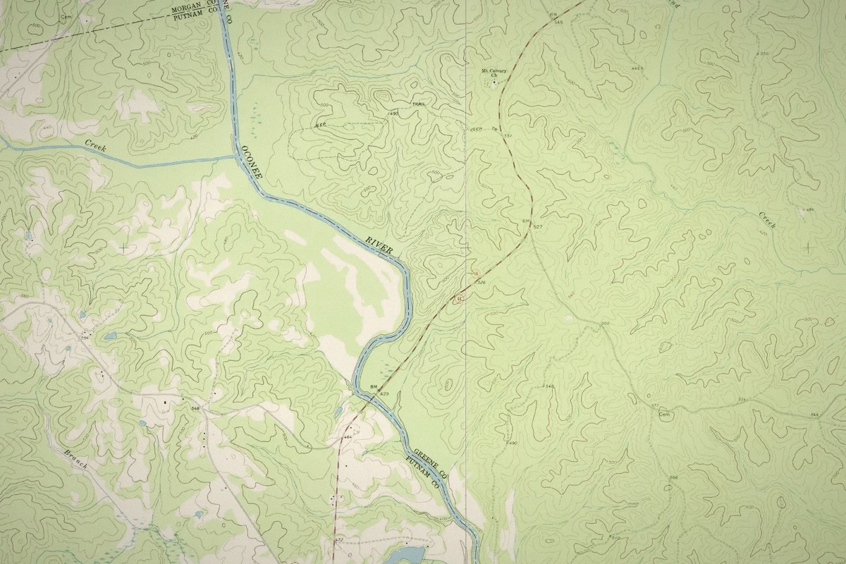
This map lays the U.S. Geological Survey’s 1972 topographic maps of the Oconee River valley over Lake Oconee as it is today. The map shows the river, creeks, farm fields and country roads that the lake covered when it filled in 1979. Press play or drag the slider to watch the river valley turn into the lake.
Key facts: Lake Oconee before the lake
- The old map on this page is six U.S. Geological Survey topographic maps drawn from aerial photographs taken in 1971, the year work started on Wallace Dam.
- They show the Oconee River valley before Lake Oconee filled in 1979: the river channel, creek valleys, farm fields, roads and churches.
- Lake Oconee’s full pool is 435 feet above sea level, so ground on the 1972 map’s 400-foot contour lies under about 35 feet of water today.
- USGS maps are public domain, and the originals can be downloaded free from USGS TopoView.
Zoom in for detail: the 1972 map shows the old roads, houses, churches and contour lines up close. It works best in full screen, especially on a phone.
Slide toward 1972 to see the valley before the water, or toward Today to see the lake. The blue line is today's shoreline.
What the 1972 Map Shows Under Lake Oconee
The 1972 map shows the Oconee River valley eight years before it flooded. On it you can find:
- The old river channel The Oconee winds down the middle of today’s lake, with the Apalachee River joining from the northwest and a braid of islands and shoals near the south end, above the dam site.
- The creek valleys that became coves Richland Creek, Sugar Creek, Beaverdam Creek, Sandy Creek, Rocky Creek and dozens of smaller branches are all on the map, each one now an arm of the lake, and several of today’s neighborhoods still carry those creek names.
- Roads, churches and crossroads Highway 44 crossed the river, small roads ran down to it at Parks Mill and other old crossings, and country churches and crossroads communities such as Veazey and Liberty dot the hills to the east.
- Farms and woods White areas on the map are open fields and pasture, and green areas are woods.
- Lake Sinclair At the far south end, the backwater of Lake Sinclair, finished in 1953, already reaches up the river below the site where Wallace Dam would be built.
Georgia Power began building Lake Oconee and Wallace Dam in September 1971 and closed the dam’s gates in March 1979. People had lived along this stretch of the Oconee for more than 10,000 years before the lake, and University of Georgia archaeologists surveyed the valley while these maps were being made.
Reading the 1972 Map as a Lake Oconee Depth Map
The thin brown contour lines on the 1972 map mark elevation in feet above sea level, every 20 feet. Lake Oconee’s full pool is 435 feet above sea level, so subtracting a contour’s number from 435 gives roughly how deep the water is over that line today.
| 1972 contour | Water over it at full pool |
|---|---|
| 420 feet | About 15 feet |
| 400 feet | About 35 feet |
| 380 feet | About 55 feet |
| 360 feet | About 75 feet |
These are the original contours of the lake bottom. Decades of silt have filled in some coves and creek mouths, so the water can be shallower than the old map suggests, and the lake rises and falls up to about a foot and a half a day as Wallace Dam pumps and generates. The map is not a navigation chart. For stumps and standing timber, Georgia Power publishes a Recreation, Fishing and Submerged Timber Map, and Lake Oconee is about 120 feet deep at its deepest point.
How to Use the Lake Oconee 1972 Map
- Fade or swipe between 1972 and today Drag the slider toward 1972 to see the old map, or toward Today to see the lake and roads as they are now. Halfway shows both, which is the easiest way to line up your own lot. Switch to Swipe and drag the line across the map instead, with 1972 on the left and today on the right. The blue line is today’s shoreline, so you can see exactly where the water reaches on the old map.
- Play Press Play and the map moves back and forth between 1972 and today on its own, so you can watch the valley fill and drain.
- Jump to a spot Pick a place from the list, such as the Highway 44 crossing or Laurens Shoals, where Wallace Dam was built, and the map flies there. The web address updates too, so you can send someone straight to that spot.
- Map or satellite Switch today’s view between a road map, where the lake shows blue and the roads are labeled, and satellite imagery.
- Full screen The button in the corner of the map gives it the whole screen, which works best on a phone.
Where the 1972 Lake Oconee Maps Come From
The old map is six U.S. Geological Survey 7.5-minute topographic quadrangles, named Greshamville, Buckhead, Greensboro, Harmony, Liberty and Rockville. Each one notes that its topography came from aerial photographs taken in 1971 and was field checked in 1972. Together they cover the whole of today’s lake, and on this page they are fitted edge to edge on top of current imagery. USGS maps are public domain, and the originals can be downloaded from USGS TopoView.
Sources
- U.S. Geological Survey, 7.5-minute topographic quadrangles for Greshamville, Buckhead, Greensboro, Harmony, Liberty and Rockville, Georgia, 1972, via USGS TopoView
- U.S. Geological Survey, The National Map imagery basemap
- Georgia Power (TRC), Historic Hydro Engineering Study Report, Wallace Dam Hydroelectric Project, 2016
- Georgia Power, Recreation, Fishing and Submerged Timber Map
Frequently Asked Questions About the Lake Oconee 1972 Map
What was Lake Oconee before it was a lake?
The Oconee River valley: a winding river with rocky shoals, creek bottoms, farm fields, woods and a handful of small roads and river crossings. Georgia Power began building Wallace Dam in 1971, and the lake filled behind it starting in 1979.
Is there a map of Lake Oconee before it was flooded?
Yes. The U.S. Geological Survey mapped the whole valley from 1971 aerial photographs, and the six 1972 maps are fitted together on this page over today’s imagery, so you can fade or swipe between the two.
Can I see what my lake lot looked like before the lake?
Yes. Zoom in to your street, then drag the slider toward 1972 or switch to Swipe. Contour lines near your shoreline also show roughly how the bottom drops off in front of your lot.
Is the 1972 map accurate for water depth today?
Roughly. It shows the original ground before the water came up, so it is a good guide to the shape of the bottom, but silt has filled in some coves since 1979. Use it for curiosity and planning, not for navigating a boat.
Curious What Was Here Before Your Lake House?
Every lot on Lake Oconee has a before picture, and I love seeing what turns up. If you’re thinking about buying or selling on the lake, let’s talk.

