

Putnam County Data Center: What We Know About Eatonton 379
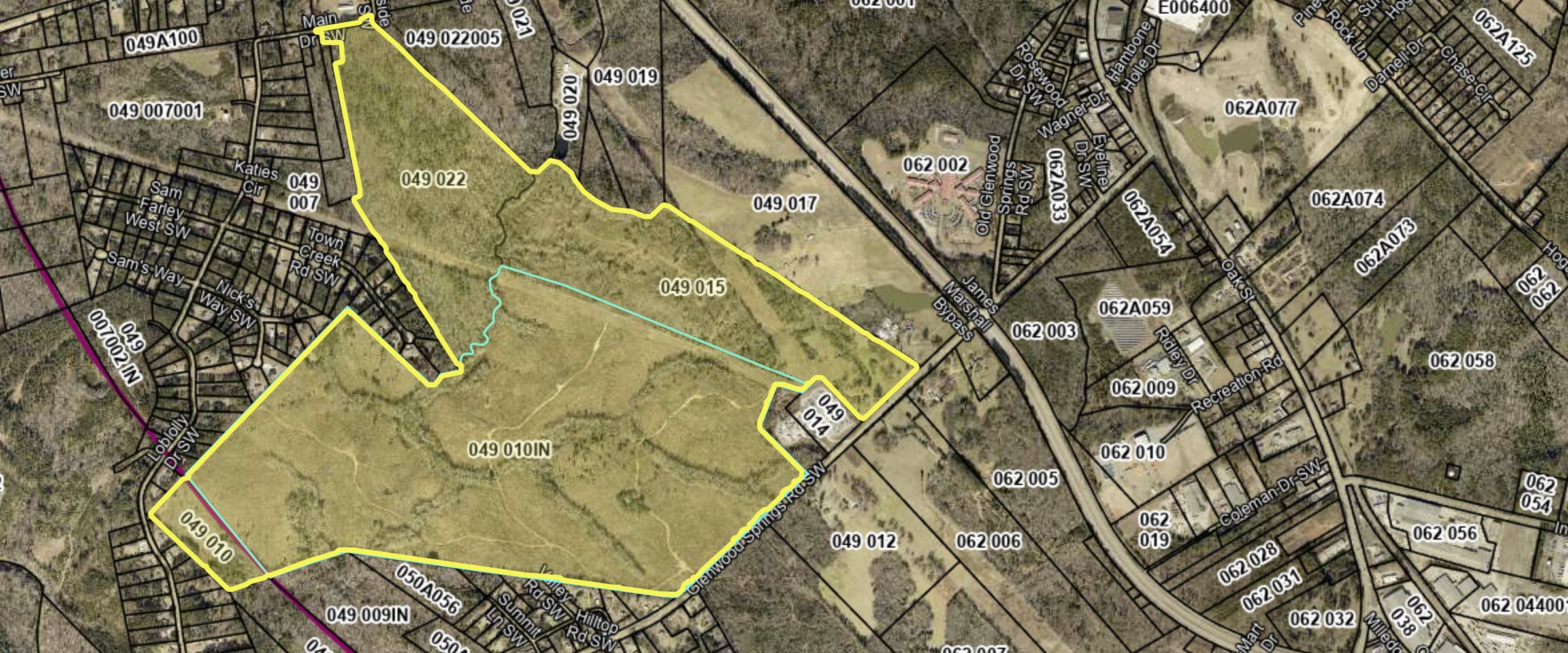
A developer has filed plans with the state for a data center campus on about 543 acres off Glenwood Springs Road, just southwest of Eatonton in Putnam County. The project is called Eatonton 379. The filing describes up to 11 buildings using up to 520 megawatts of power, about $3.5 billion in construction and a 2031 finish. Nothing has been approved. The land is zoned agricultural, the county has a moratorium on data center permits through December 4, 2026, and no power company has agreed to serve it. The site is about nine and a half miles from the nearest Lake Oconee shoreline.
Latest update: November 2026
- Eatonton 379, LLC filed a Development of Regional Impact review with the state on October 26, 2026. It is DRI #4861, reviewed by the Middle Georgia Regional Commission.
- Putnam County’s moratorium on data center, battery storage and solar permits started August 7 and has been extended twice, most recently on November 6 to December 4, 2026.
- The county is taking public comments on a proposed data center ordinance, Chapter 53.
- The company that would use the campus hasn’t been named.
In this guide
Where the Putnam County Data Center Would Go
The land is on Glenwood Springs Road, west of U.S. 441 South and about two miles southwest of downtown Eatonton, outside the city limits. It is mostly woods and open fields, taxed as agricultural land, and the driveways in the plan come off Glenwood Springs Road. The filing places the center of the site at 33.3044, -83.4065.
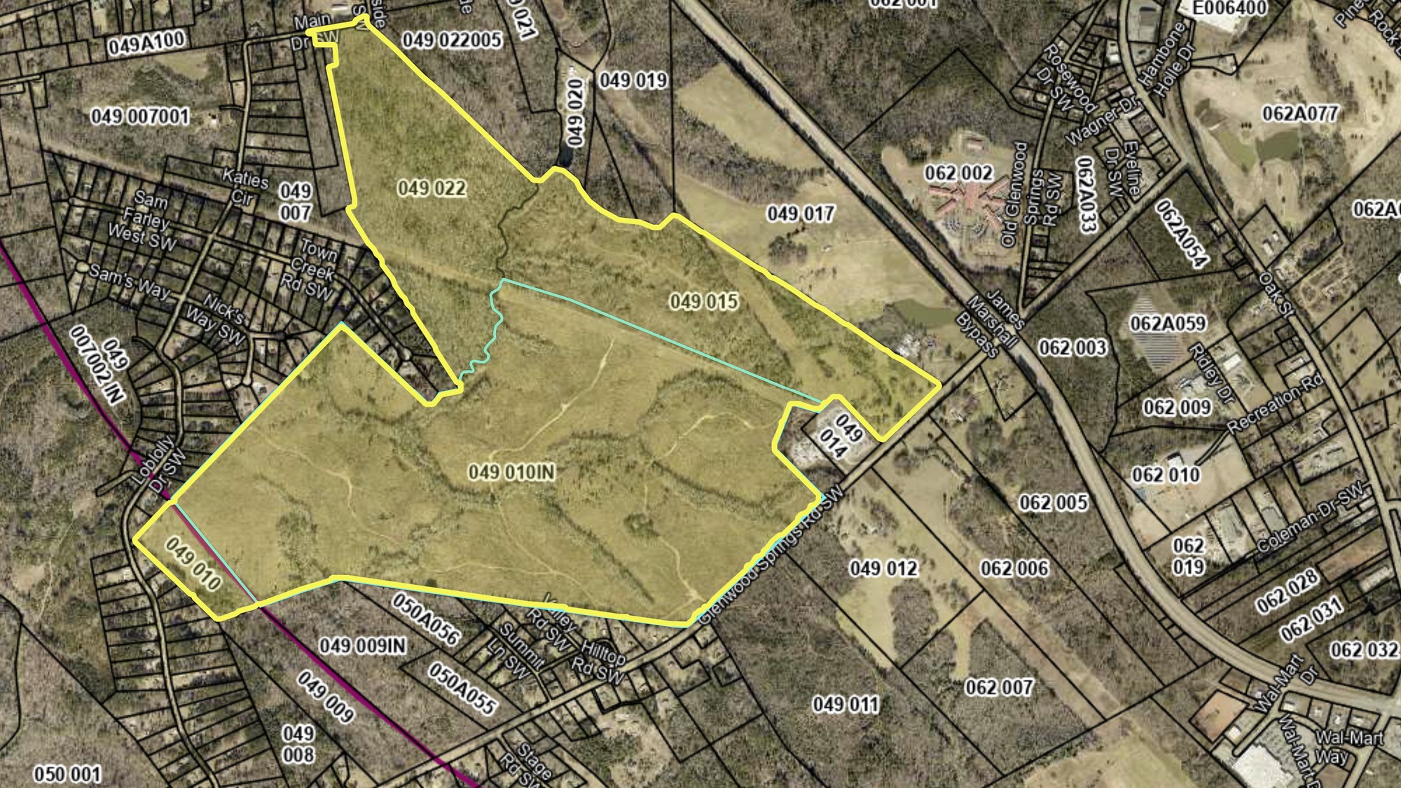
It isn’t on the lake. The nearest Lake Oconee shoreline is about nine and a half miles to the northeast as the crow flies, and the Little River, which runs down to Lake Sinclair, is about two miles to the west. Most of Putnam County’s Lake Oconee neighborhoods around Eatonton are on the far side of town from it, off Highway 16 and Highway 44.
What Eatonton 379 Is Proposing
All of these numbers come from the developer’s own state filing.
| Buildings | Up to 11, about 3.5 million square feet |
| Land | About 543 acres, 40% of it built on or paved |
| Power | Up to 520 megawatts peak, with substations on site |
| Water | About 75,000 gallons a day from the Eatonton-Putnam Water and Sewer Authority |
| Traffic | About 2,560 new trips a day |
| Jobs | About 100 full-time |
| Local taxes | About $37.35 million a year, by the developer’s estimate |
| Cost | About $3.5 billion at build-out |
| Completion | 2031 |
Eatonton 379 DRI #4861 filing, October 26, 2026, via DataCenterFeed
Georgia requires a Development of Regional Impact review for projects this size so that neighboring counties can weigh in. The regional commission has up to 30 days to collect comments and issue its findings, but it can’t approve or stop anything. That decision belongs to Putnam County.
Who Is Behind the Eatonton Data Center
The company behind the filing is Eatonton 379, LLC. It was registered with the Georgia Secretary of State on July 28, 2026, ten days before the county’s moratorium. Its office address and registered agent both belong to a corporate services firm in Alpharetta that handles filings for more than a thousand Georgia companies, so the state records don’t say who owns it. Atlanta attorney Steven L. Jones is listed as the contact. Big data center projects are often set up this way, and the company that will actually use the buildings usually isn’t named until the zoning is settled.
The state filing lists four landowners: HPS Real Estate, LLC, Dial Farm Holdings LLC and two individuals. Putnam County property records show HPS Real Estate holds the largest share, three tracts on Glenwood Springs Road totaling about 379 acres, which lines up with the project’s name. That land passed to HPS in 2019 through a family estate. Dial Farm Holdings bought an 88-acre tract in 2023, and the individuals bought a 95-acre tract in December 2025. According to county records, none of it has been sold to Eatonton 379, LLC.
Putnam County’s Data Center Moratorium and Proposed Rules
Putnam County commissioners put a three-month moratorium on land development permits for data centers, battery energy storage and solar systems on August 7, 2026. On October 21 they extended it to November 17, and on November 6 they extended it again to December 4. While it’s in place the county isn’t issuing those permits, and it’s using the time to write a new ordinance, Chapter 53, “Energy Creation, Energy Storage, and Digital Infrastructure.”
Under the draft, a data center on agricultural land like this site would need a conditional use permit. It would only be allowed outright in industrial and public zoning. The draft would also require:
- A 200-foot buffer along any property line next to residential zoning, with evergreen screening at least 15 feet tall
- Buildings no taller than 75 feet
- Noise no louder than 55 decibels at a residential property line, with noise studies before construction and before opening
- Closed-loop cooling, so water is recirculated rather than evaporated
- A decommissioning bond covering the cost of removing the buildings
The county is taking public comments on the draft through a form on its data center moratorium page. It hasn’t said whether commissioners plan to adopt it before the moratorium runs out or extend the moratorium again.
Power and Water at the Putnam Co. Data Center
At its peak the campus could use 520 megawatts. For comparison, Wallace Dam, the Georgia Power plant that forms Lake Oconee, is rated at 321 megawatts. The filing names Tri-County EMC and Georgia Power as possible suppliers. Neither has signed on, and the developer has asked for a study of the transmission lines. The filing also mentions generating some power on site but doesn’t say how.
If Georgia Power ends up serving it, a 2025 Public Service Commission rule comes into play. Any new customer over 100 megawatts has its contract reviewed by the Commission and pays for its own transmission and distribution upgrades as they are built, so the cost doesn’t land on residential bills.
The filing estimates about 75,000 gallons of water a day. That is low for a data center because it assumes closed-loop cooling, which recirculates the water instead of evaporating it, and the county’s draft ordinance would require that kind of cooling. Earlier in 2026, the Middle Georgia Regional Commission reported that the county’s water and sewer capacity should hold up through 2060.
What the Eatonton Data Center Means for Lake Oconee
The campus wouldn’t be on the lake or next to any lake neighborhood. The effects closest to home would be construction traffic on Glenwood Springs Road and U.S. 441, and any new power lines and substations built to serve it.
The developer estimates the campus would pay about $37.35 million a year in local taxes. No tax deal with the county’s development authority has been made public yet, and any tax break would lower that figure.
Update Log
- November 2026: First published, covering the October 26 state filing, the land records, the moratorium extensions to November 17 and December 4, and the draft Chapter 53 ordinance.
Frequently Asked Questions About the Putnam County Data Center
Is there a data center coming to Lake Oconee?
One is proposed in Putnam County, but not on the lake. The Eatonton 379 site is off Glenwood Springs Road southwest of Eatonton, about nine and a half miles from the nearest Lake Oconee shoreline. It still needs county approval and a power supplier.
Where is the Eatonton data center?
On about 543 acres along Glenwood Springs Road in unincorporated Putnam County, west of U.S. 441 South and about two miles southwest of downtown Eatonton.
Who is building the Putnam Co. data center?
Eatonton 379, LLC filed the plans. It was formed in July 2026, and its state records list a corporate services firm instead of its owners. The company that would use the campus hasn’t been named.
Has Putnam County approved the data center?
No. The land is zoned agricultural, and the county has a moratorium on data center permits through December 4, 2026, while it finishes a new ordinance. The state filing is an advisory review, not an approval.
How much power and water would it use?
Up to 520 megawatts at peak and about 75,000 gallons of water a day, according to the developer’s filing. For comparison, Wallace Dam on Lake Oconee is rated at 321 megawatts.
When would the Eatonton 379 data center open?
The filing projects completion in 2031, assuming it gets zoning approval and a power supply.
Questions About Putnam County Real Estate?
If you own in Putnam County or are thinking about buying on this side of the lake, ask me what has been filed and I’ll tell you where things stand.
Project figures come from the Eatonton 379 Development of Regional Impact filing (DRI #4861), the ownership details from Putnam County property records and Georgia Secretary of State business records, and the moratorium and draft ordinance from Putnam County. Power and tax figures are the developer’s estimates. Distances are measured in a straight line from the filing’s coordinates. Last updated November 2026.
